Explore This Trek In Details
Version: Standard 10D/9N
10 Days / 9 Nights Strenuous Minimum Altitude: 1920m Maximum Altitude: 5450m Starts At: Sankri Ends At: Shimla
Route
Sankri → Taluka → Gangaad → Chillur Gad → Osla → Halche → Boslo → Har Ki Dun → Maninda Tal → Rataa Tho → Saun Bera → Lamjunga → Borasu Pass → Bonga → Rani Kanda → Chitkul → Shimla
Terrain
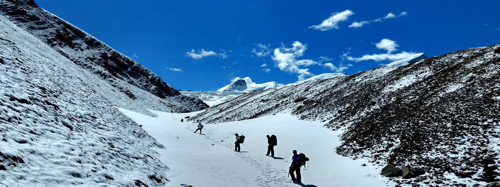
glaciermeadowsmorainescree
10 Trekking Days
7 Camping | 3 Hotel | 0 Homestay Nights
33 Km Trekking Distance | 0 Km Driving Distance
▲ Day 1 From Dehradoon to SankriTrek Day
From Dehradoon (445m / 1460 ft ) To Sankri (1920m / 6299 ft ) Via Purola (1550m / 5085 ft ), Mori (1150m / 3773 ft ) - 8-9 Hrs.
Overnight In: Sankri (1920m / 6299 ft )
Accommodation: Hotel
Meals Included: Evening Tea Snacks, Soup, Dinner, Dessert, Hot Drinks
Early morning board your vehicles to take one of the very picturesque Himalayan drive following the Yamuna and the Tons river. You may stop by at Mussurie for having a quick breakfast and at Kempty falls enroute to start with the fun game right away.
After a drive of some 7 hours, you will arrive in Sankri by evening. On reaching, one of our representative will greet you and guide you to your hotel room. Once you are settled and freshened up, we meet over for evening Tea and Snacks. That's where we get introduced with the Team, issue you personal equipments for extra hygiene and safety, and share latest updates for the Har Ki Dun trek in short.
Our dinner gets ready by that time, and we get ready for a savoury dinner cooked by our expert cook hired locally.
Your trek leader and guide will share the timings for tomorrow.
- Day 1
- 445 - Dehradoon
- Day 1
- 1550 - Purola
- Day 1
- 1150 - Mori
- Day 1
- 1920 - Sankri
8 - 9hrs.▲ Day 2 From Sankri to Chillur GadTrek Day
From Sankri (1920m / 6299 ft ) To Chillur Gad (2500m / 8202 ft ) Via Taluka (1800m / 5906 ft ), Gangaad (2400m / 7874 ft ) - 5-6 Hrs. 10 Kms
Overnight In: Chillur Gad (2500m / 8202 ft )
Accommodation: Camping
Meals Included: Morning Tea, Breakfast, Lunch, Evening Tea Snacks, Soup, Dinner, Dessert, Hot Drinks
Today after breakfast, we start our journey towards Taluka. It will be done on an offload camper. The road is very thrilling and beautiful at the same time. One side of the road is completely exposed to abyss while the other side keep crossing rock fall, landslide zones and small streams which become very difficult at times.
After we reach Taluka, we meet the remaining member of our support crew, mainly the horseman who loads the trek equipment and ration on the mules, while we start the trek with the guide. Its a gentle walk following the gushing Har Ki Dun river.
- Day 2
- 1920 - Sankri
- Day 2
- 1800 - Taluka
- Day 2
- 2400 - Gangaad
- Day 2
- 2500 - Chillur Gad
10Km, 5-6hrs.▲ Day 3 From Chillud Gad to BosloTrek Day
From Chillud Gad (2500m / 8202 ft ) To Boslo (3150m / 10335 ft ) Via Osla (2800m / 9186 ft ), Halche (2900m / 9514 ft ) - 5-6 Hrs. 12 Kms
Overnight In: Boslo (3150m / 10335 ft )
Accommodation: Camping
Meals Included: Morning Tea, Breakfast, Lunch, Evening Tea Snacks, Soup, Dinner, Dessert, Hot Drinks
Today's walk too follows the Har Ki Dun river till Seema where we cross the suspension bridge to go to the true left of the river. We continue t follow the river up till the Kalkati Dhar. The trek is steep in a few sections today. The Campsite of Kalkati Dhar is very beautiful with the Har Ki Dun peak and the Hata Peak hovering over the beautiful meadow of Kalkati Dhar surrounded by dense jungle all around. The river is down below and can only be heard from here. From the camp of Halche, we could also see the twin peaks of Bandarpoonch.
- Day 3
- 2500 - Chillud Gad
- Day 3
- 2800 - Osla
- Day 3
- 2900 - Halche
- Day 3
- 3150 - Boslo
12Km, 5 - 6hrs.▲ Day 4 From Boslo to Maninda TalTrek Day
From Boslo (3150m / 10335 ft ) To Maninda Tal (3800m / 12467 ft ) Via Har Ki Dun (3600m / 11811 ft ) - 4-5 Hrs. 7 Kms
Overnight In: Maninda Tal (3800m / 12467 ft )
Accommodation: Camping
Meals Included: Morning Tea, Breakfast, Lunch, Evening Tea Snacks, Soup, Dinner, Dessert, Hot Drinks
Today we climb gently to Har Ki Dun following a very beautiful trek, passing by a few waterfalls and lovely openings in the forest. Har Ki Dun is indeed a beautiful place surrounded by beautiful snow-clad peaks and a stream silently flowing down right in the middle of the campsite. After spending some time here, we move forward to yet another beautiful campsite of Maninda Tal.
- Day 4
- 3150 - Boslo
- Day 4
- 3600 - Har Ki Dun
- Day 4
- 3800 - Maninda Tal
7Km, 4 - 5hrs.▲ Day 5 From Maninda Tal to Rataa ThoTrek Day
From Maninda Tal (3800m / 12467 ft ) To Rataa Tho (4000m / 13123 ft ) - 4-5 Hrs. 4 Kms
Overnight In: Rataa Tho (4000m / 13123 ft )
Accommodation: Camping
Meals Included: Morning Tea, Breakfast, Lunch, Evening Tea Snacks, Soup, Dinner, Dessert, Hot Drinks
Todays day doubles up as a reserved day incase weather plays foul or due to any other unplanned event. We can skip over this day. It is here to help us acclimatize well and we utilize it well to explore the Jaundhar Glacier region in the morning. You will be taken aback by the sheer beauty of the landscape here. We return before lunch, and a little rest after lunch, we shift our camp ti Rataa Tho sleeping little beyond 4000 meters today. Its the most important day for the success of this trek.
- Day 5
- 3800 - Maninda Tal
- Day 5
- 4000 - Rataa Tho
4Km, 4 - 5hrs.▲ Day 6 From Rataa Tho to Saun BeraTrek Day
From Rataa Tho (4000m / 13123 ft ) To Saun Bera (4540m / 14895 ft ) - 3-4 Hrs.
Overnight In: Saun Bera (4540m / 14895 ft )
Accommodation: Camping
Meals Included: Morning Tea, Breakfast, Lunch, Evening Tea Snacks, Soup, Dinner, Dessert, Hot Drinks
From here the trek changes its feel and starts to offer its challenges firstly in getting steeper, and the terain changes to that of a typical glacial moraine filled with boulders and scree zones. An effort of some 4 hours brings us to the camp site of Sawan Bedha
- Day 6
- 4000 - Rataa Tho
- Day 6
- 4540 - Saun Bera
3 - 4hrs.▲ Day 7 From Saun Bera to LamjungaTrek Day
From Saun Bera (4540m / 14895 ft ) To Lamjunga (4870m / 15978 ft ) - 4-5 Hrs.
Overnight In: Lamjunga (4870m / 15978 ft )
Accommodation: Camping
Meals Included: Morning Tea, Breakfast, Lunch, Evening Tea Snacks, Soup, Dinner, Dessert, Hot Drinks
As a penultimate day before the Pass Crossing day, this day serves as the last chocolate bar before hitting the trail leading to the summit of the pass. A short day at an altitude above 4500 meters. It makes sense to make it shorter. The terrain gives no relief though.
- Day 7
- 4540 - Saun Bera
- Day 7
- 4870 - Lamjunga
4 - 5hrs.▲ Day 8 From Lamjunga to Bonga Trek Day
From Lamjunga (4870m / 15978 ft ) To Bonga (4480m / 14698 ft ) Via Borasu Pass (5450m / 17881 ft ) - 8-9 Hrs.
Overnight In: Bonga (4480m / 14698 ft )
Accommodation: Camping
Meals Included: Morning Tea, Breakfast, Lunch, Evening Tea Snacks, Soup, Dinner, Dessert, Hot Drinks
The toughest day of the trek. An effort of some 3 hours over steep terrain of snow over scree zone takes us to the summit of the pass. From here, you can see back your trail and start imagining your past days and the effort you put to reach till here. However, things are not complete yet. There is a tactful descend to negotiate which still maintains the difficulty of the trek. A campsite exists just after descending down the pass, but it is advisable to reach the welcoming meadows of Bonga and rest out the night.
- Day 8
- 4870 - Lamjunga
- Day 8
- 5450 - Borasu Pass
- Day 8
- 4480 - Bonga
8 - 9hrs.▲ Day 9 From Bonga to ChitkulTrek Day
From Bonga (4480m / 14698 ft ) To Chitkul (3490m / 11450 ft ) Via Rani Kanda (3950m / 12959 ft ) - 6-7 Hrs.
Overnight In: Chitkul (3490m / 11450 ft )
Accommodation: Hotel
Meals Included: Morning Tea, Breakfast, Lunch, Evening Tea Snacks, Soup, Dinner, Dessert, Hot Drinks
Having past the most difficult day of the trek this feels like a relaxing day as the trail slowly starts to show the signs of nearing generous terrains and civilization.
- Day 9
- 4480 - Bonga
- Day 9
- 3950 - Rani Kanda
- Day 9
- 3490 - Chitkul
6 - 7hrs.▲ Day 10 From Chitkul to ShimlaTrek Day
From Chitkul (3490m / 11450 ft ) To Shimla (2250m / 7382 ft ) - 5-6 Hrs.
Overnight In: Shimla (2250m / 7382 ft )
Accommodation: Hotel
Meals Included: Morning tea, Breakfast
We leave for Shimla today in the morning and then onwards to Chandigarh or Delhi
- Day 10
- 3490 - Chitkul
- Day 10
- 2250 - Shimla
5 - 6hrs.
Other Customizable Variations of the Borasu Pass Trek
We are not limited to just these options. These are simply some of the most commonly requested and well planned customizations.
If you have a different requirement, talk to us.
We only organize lesser done, uncrowded, customizable and personalized, small-group private trekking tours in the Himalayas with full safety protocol in place. All customizations will be guided by this principle only.
Swipe →
Top Reasons to Choose the Borasu Pass Trek
- The Borasu Pass lies on the border of Himachal Pradesh and Uttrakhand and it served as the ancient trade route and Gateway Of Cultural Exchanges between Kinnaur, Tibet and Jaunsar.
- The altitude of Borasu Pass, also known as Barasu Pass, is above 5400 meters and is a very high altitude pass crossing trek in the Himalayas.
- The terrain of this trek goes through a dense forest of tall coniferous trees, which transforms into alpine grasslands, scree zones, glacial moraines and then the crevassed glaciers on both sides. It definitely makes an engaging and strenuous trek all the way to Chitkul starting from the beautiful hamlet of Sankri.
- Zupica glaciers is a contributary water source of the Baspa river, which originates from the Baspa Bamak higher up on the same valley.
- The hospitality of both the valleys that the Borasu Pass connects is awesome and most welcoming for a traveller. The people here are strong, hardy but always with a smile on their face.
- Both of the valleys of Sankri and Kinnaur have their unique dialect and cuisines. The food they cook is unique, tasty and very organic.
- On this trek, we pass by the campsite of the very popular Har Ki Dun and Kalkati Dhar. Both these campsites are wonderful place to be in and very photogenic.
- The Swargarohini massif looks gigantic from the camp of Har Ki Dun and on the excursion to the Jaundhar Glacier viewpoint. It is a massif of 6 peaks, 4 of which are visible from Sankri.
- From the campsite of Halche, before reaching Kalkati Dhar, we can even see the twin peaks of Bandarpoonch and Kalanag. Both demonstrate epic Himalayan glory.
- Maninda Tal is a small lake formed by the blocked water of the Borasu Gad. It is very serene, but what makes it a highly revered place is the surrounding mountains, meadows and valleys. It is very beautiful and camping here makes it really worth it.
Altitude and Acclimatization Profile For The Borasu Pass Trek
- Day 1
- D1Dehradoon
- Day 1
- Purola
- Day 1
- Mori
- Day 2
- D2Sankri
- Day 2
- Taluka
- Day 2
- Gangaad
- Day 3
- D3Chillur Gad
- Day 3
- Osla
- Day 3
- Halche
- Day 4
- D4Boslo
- Day 4
- Har Ki Dun
- Day 5
- D5Maninda Tal
- Day 6
- D6Rataa Tho
- Day 7
- D7Saun Bera
- Day 8
- D8Lamjunga
- Day 8
- Borasu Pass
- Day 9
- D9Bonga
- Day 9
- Rani Kanda
- Day 10
- D10Chitkul
- Day 11
- Shimla
Frequently Asked Questions
What is the best time to do the Borasu Pass Trek?
Best months: May, Jun, Sep, Oct
Is mobile network available on the Borasu Pass Trek?
Quick answer: BSNL signals in Sankri. Rare unguaranteed BSNL signals while on trek and pass top
Is internet available on the Borasu Pass Trek?
What type of trek is this?
Circuit Trek
In this type of trek, the entry point and exit point is different. You trek to reach a new point. Generally involves a pass crossing to enter a new valley.
What is the accommodation type on this trek?
Camping
Camping treks are those where nights are spent in tents pitched at designated campsites. Camps are chosen for safety and practicality (stable ground, water availability, weather exposure, and minimal ecological impact). This style offers the most raw mountain experience and flexible route planning, but comfort depends on terrain and conditions.
What kind of toilet facilities can I expect on this trek?
Toilet tents are used at campsites (dry-pit / cat-hole system as per terrain and local regulations). Some camps may have basic fixed toilets near village camps, but do not expect permanent facilities.
How is food served during the trek?
Fresh meals are cooked by the trek staff at camp. Food is served hot in a common dining setup (dining tent or open area). Meals are generally simple, nutritious, and high-energy; menu depends on package and logistics.
How is human waste managed on this trek?
Human waste is handled using toilet tents and designated pits/cat-holes at safe distance from water sources. Sites are selected and managed to reduce contamination; toilet paper and hygiene waste are carried out where feasible or disposed as per local guidelines.
How is food waste managed on this trek?
Food waste is minimized through planned portions. Biodegradable waste is disposed responsibly away from water sources or carried down where required. Leftovers are avoided; nothing is dumped into streams.
How is plastic waste handled on this trek?
Plastic waste is segregated and carried back to the roadhead for proper disposal. Trekkers are encouraged to use refillable bottles; single-use plastics are discouraged/controlled.
How do you follow Leave No Trace principles on this trek?
Camps are left cleaner than found. Waste is segregated and carried out, trails are respected, water sources are protected, and noise is kept low. No littering, no washing with soap near streams, and no disturbance to wildlife or local culture.
What type of terrain can I expect on the Borasu Pass Trek?
meadows, moraine, scree, glacier
Is cloakroom / luggage storage available for the Borasu Pass Trek?
No. Cloakroom or luggage storage is not available for this trek.
What kind of food is served on the Borasu Pass Trek?
Indian, Neplese
We serve a mix of continental-style trek meals as well as simple, freshly cooked home-style food.
The exact menu and style of meals may vary depending on the trek itinerary, region, and the package you are booked on.
Meal inclusions typically cover:
- Breakfast, Lunch, and Dinner (BLD)
- Two tea breaks daily (morning and evening)
- Soup in the evening
- Fresh salads where feasible
- Dessert on select days
- Hot night beverage / tonic before sleeping
Please note that detailed, day-wise meal information is mentioned in the respective day’s itinerary wherever applicable.
Where does the Borasu Pass Trek start?
Where does the Borasu Pass Trek end?
What is the grade / difficulty of the Borasu Pass Trek?
Strenuous
The trek duration each day may span from 5 - 8 hours, and may go up to to 8 - 9 on few days. The trail involves steep ascents and descents. Good fitness are demand of these treks, and trekkers must involve themselves in cardio exercises regularly to do these treks comfortably. Sleeping altitude may go above 4000 meters or little above it on couple of days, but not more than that. The trail might go as high as 4500 - 5200 meters. These trek are remote and evacuation might not be possible from all the campsites
What is the duration of the Borasu Pass Trek?
10 Days, 9 Nights, Sankri to Chitkul
Is the Borasu Pass Trek inside or near a national park?
Govind Pashu Vihar National Park and Sanctuary
Thursday, June 11, 2026 2:43:53 PM